Met masts and wind monitoring
Accurate data is essential to your project’s success
Developing and operating an investment-grade asset depends on robust, accurate and bankable data.
Proven and dependable data from traditional met-masts have been the cornerstone of the modern wind industry since the late 1980’s. Understanding wind flow at different heights using advanced anemometry, is at the core of Dulas’s DNA since 1988 when we installed our first anemometer and data logger system at the Cemmaes wind farm, Wales.
The enduring appeal of traditional met-masts compared to new technologies such as LiDAR and SoDAR, is much discussed within the wind industry. New challengers are often flexible and certainly have their place, however so far the wind industry continues to benchmark wind energy performance using fixed tower anemometry techniques that are well established and have known uncertainty bands.
Find out more about Dulas’s Wind Monitoring turnkey services for traditional met-masts on the pages below, or click the tab below to jump straight to our product line.
Turnkey Installation
Our complete installation and maintenance service includes:
- A full turnkey mast installation service, including ongoing refurbishment, equipment storage, inspection, maintenance, re-certification and decommissioning
- Installation of tilt-up met masts (10m – 90m) with custom dataloggers
- Lattice tower installations (40m – 160m)
- Rental of industry-leading Vaisala Triton SoDAR and WindCube LiDAR remote sensing systems
- Expert management of client-owned SoDAR and LiDAR systems, including deployment, storage and data processing
- Gathering data required for power curve testing
- Onshore and offshore instrumentation installations
Data as a Service
Benefitting from many years of experience working on challenging sites across the UK, Dulas’s team of IRATA-3 trained engineers provide a complete installation and maintenance service for your onshore and offshore measurement equipment. Find out more here about how we can reduce your on-site risk and bring cost efficiency with our new data as a service package from Dulas.
Once collected, reliable resource and performance data plays a key role in informing the decisions with a bearing on the long-term success of your project.
In order to help you make the most of your data, Dulas’s in-house team of data analysts provide expert screening, collection and archiving of data from onshore and offshore wind measurement equipment. Dulas’s remote communication systems have been developed over many years to provide you with the very best reporting from both met masts and remote sensing devices.
Turnkey Remote Sensing
Cost pressures on wind farm development in mature markets now means that data collection and analysis in the development stage needs to be efficient, easy and expedient. In addition with noise sensitivity an important consideration in the planning process, Dulas is able to deploy remote sensing technology and its expertise to ensure that turbine developments are able to meet the latest regulatory requirements.
In emerging markets, where wind energy is now also proliferating into more remote regions, remote sensing needs to be completed by equipment that is able to be transported easily, with modest levels of power consumption. Dulas offers the customer the option of robust Triton acoustic measurement devices, and advanced WindCube LiDAR measurements from Vaisala. LiDAR stands for Light Detection And Ranging, and these systems deploy an infrared-laser that detects reflections from tiny particles in the air as a means to measure the wind velocity.
Dulas is able to provide remote sensing services to on- and offshore wind developments, starting from heights of 10 metres and reaching 200 metres or more.
WindCube LiDARs may be used independently as measuring devices, or in conjunction with conventional meteorological masts, at the same time as measuring multiple heights across the entire swept area of a turbine blade.
Dulas Data as a service is available for both traditional met-mast anemometry or remote sensing campaigns. Dulas will offer you availability guarantees, call-out schedules and operational and field maintenance services. Please get in touch to find out more.
Remote Sensing
Always have the latest data at hand
Choose from advanced LiDAR remote sensing systems for the most accurate remote measurements available today, or economical SoDAR units suitable for short term deployments and initial feasibility studies.
Remote Sensing
Always have the latest data at hand
Choose from advanced LiDAR remote sensing systems for the most accurate remote measurements available today, or economical SoDAR units suitable for short term deployments and initial feasibility studies.
Turnkey Remote Sensing
Cost pressures on wind farm development in mature markets now means that data collection and analysis in the development stage needs to be efficient, easy and expedient. In addition with noise sensitivity an important consideration in the planning process, Dulas is able to deploy remote sensing technology and its expertise to ensure that turbine developments are able to meet the latest regulatory requirements.
In emerging markets, where wind energy is now also proliferating into more remote regions, remote sensing needs to be completed by equipment that is able to be transported easily, and have very low levels of power usage. Dulas offers the customer the option of robust Triton acoustic measurement devices by Vaisala, or advanced WindCube LiDAR measurements from Leosphere. LiDAR stands for Light Detection And Ranging and these systems deploy an infrared-laser that detects reflections from tiny particles in the air as a means to measure the wind velocity.
Dulas is able to provide remote sensing services to on- and offshore wind developments, ranging from turbine hub heights of 10metres, all the way up to 200metres and more.
WindCube LiDARs may be used independently as measuring devices, or in conjunction with conventional meteorological masts, at the same time as measuring multiple heights across the entire swept area of a turbine blade.
Dulas Data as a service is available for both traditional met-mast anemometry or remote sensing campaigns. Dulas will offer you availability guarantees, call-out schedules and operational and field maintenance services. Please get in touch to find out more.
Met mast verification and refurbishment
Ensure your data accuracy over time
Despite the importance of meteorological masts during wind prospecting, once the wind farm is fully operational, meteorological masts can become a neglected asset, as production priorities and operations and maintenance activity on turbines take precedence.
Over time, neglected operational masts can have the potential to lose data accuracy, thereby providing owners and secondary investors with incorrect data, which ultimately affects project returns, the investment grade of the development, and client reporting.
Refurbishment of operational systems is possible in many cases and it can be done with the help of our experienced climbing crews that will remove instruments, undertake the refurbishment and recalibration and then return them to service.
To help wind farm owners and asset managers understand the data accuracy of met-masts during the development phase and (ultimately protect their margins), Dulas also offers a ground based verification service using our LiDAR units. These are able to identify inaccuracies in the met-mast measurements which may have crept in over time during their deployment in the field. The advantage of this approach is that the accuracy and functionality of meteorological masts can be assessed in the field without having to disassemble and lower the structure and take it out of service. In addition, LiDAR measurements are able to capture data above the height of the met-mast, up to around 200m or more, that helps the developer to understand to wind shear models that are used to predict the wind speed up to the tip height of the turbine.
For expediency the LiDAR can be deployed in less than 4 weeks and are able to measure wind speeds and characteristics from 10 metres to 200 metres or more – ensuring correlations may be performed across a range of suitable heights.
To help wind farm owners and asset managers maintain the data accuracy of their masts, and ultimately protect their margins, Dulas has launched a new service with our LiDAR units. Using the finance-grade lidar systems that are able to detect many of the causes of inaccuracy in the met mast and validate wind shear models used above mast height, Dulas is able to assess the accuracy and functionality of meteorological masts without having to disassemble and lower the structure.
For expediency, the LiDAR can be deployed for less than 4 weeks, and is able to measure wind speeds and characteristics from as low as 10 metres to as high as 200 metres – ensuring correlations may be performed on even the shortest masts.
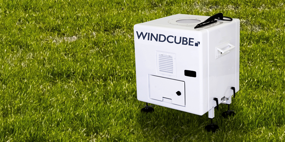
Dulas LiDARs are factory verified and are able to:
- Confirm any deterioration in anemometry calibration over time
- Discover misalignment of anemometry with respect to the mast
- Detect anemometry failings during freezing temperatures


